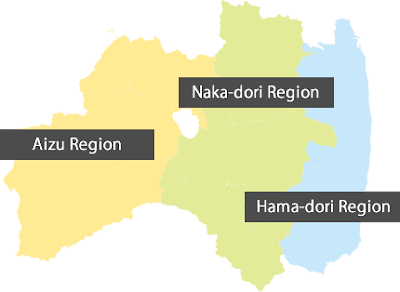
[English] Divisions of Fukushima: Aizu, Naka Dori, and Hama Dori
Fukushima prefecture is geographically divided to three vertical areas. From west to east, there is Aizu Region, Naka-dori Region, and Hama-dori Region.
Three areas are divided by mountain ranges. There is the Oou Mountain Range between Aizu and Naka-dori. Some of mountains in the Oou Mountain Range are still active under the Nasu Volcanic Belt.
And, there is the Abukuma Mountain Range that is not volcanic background between Naka-dori and Hama-dori. The Abukuma Mountain Range has more gently slope and lower altitude than the Oou Mountain Range.
In this vertical division among three areas, peoples in three areas have little feeling of solidarity or sense of unity as Fukushima prefecture because their interactions had been disturbed by the Oou Mountain Range and the Abukuma Mountain Range.
Fukushima prefecture is the third largest prefecture in Japan, after Hokkaido and Iwate. So, we should be careful to use the name of Fukushima as prefecture or city. If you talk on Fukushima, we should ask which Fukushima you mean.
Nuclear power plants of Tepco has been called Fukushima Daiichi (the 1st) and Fukushima Daini (the 2nd), not called by the name of town as Futaba, Okuma, Naraha and Tomioka. Those nuclear power plants locate only in Hama-dori Region.
But, the name of Fukushima would look like to cover all Fukushima prefecture. Some people in Naka-dori and Aizu felt to be forcefully involved in the name of Fukushima under tragedy accident of nuclear power plants in Hama-dori at that time.
Because of rumor damage by the name of Fukushima, all three regions faced to the same difficulties. Refugees from Hama-dori were accepted by Aizu and Naka-dori. Ironically, this difficult situation might create a kind of solidarity feeling among three regions as Fukushima prefecture.


Comments
Post a Comment